


 272 / 540

271
raised promontory is also the highest geograph-
ic point and would later become the site of the
exclusive residential neighborhood of Gazcue
15
in the mid-1950s. It is an extremely high point
making up the third stratigraphic layer of the lo-
cal topography, a natural feature that emerges
from the reef-studded coastline and meanders
throughout the entire city’s bedrock.
At the beginning of the twentieth century,
the distinguished townsman and landowner Fé-
lix María Lluberes made a significant donation
to the country in order to build the campus for
the former Universidad Santo Tomás de Aqui-
no, now the Autonomous University of Santo
Domingo. A large American-style ranch was
constructed high upon the foundation together
with a vaulted perimetral gallery, which opened
onto the east, the south, and the southwest. It
had gabled and slanted roofs and attics, consist-
ing of two floors, with the gallery recreated on
the top floor following the same dimensions
and formal arrangement as the ground floor. With its vast and yet untouched areas and its permanence as
the city center, the expanse of Gazcue established a residential precedent for the entire city. It was developed
with some reservations toward the beginning of the twentieth century on plots from an extensive property
belonging to the magnate Francisco Gazcue. A real estate inheritance would later divide the area into parcels
belonging to various descendants of several wealthy families by the end of the 19th century.
General Casimiro N. de Moya in his illustrious “Plan for the City and Surroundings of Santo Domingo”
from May of 1900 clearly pinpoints improvements for the villa of Gazcue, and referred to the neighborhood
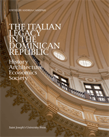
The General Customs
Office, which
later became the
“Presidential Mansion.”
© D’Alessandro Tavárez
family collection. Courtesy
of José Chez Checo
THE ITALIAN ENGINEER GUIDO D’ALESSANDRO LOMBARDI