


 242 / 540

241
THE WALLS OF SANTO DOMINGO AND DOCUMENTATION OF THE CONSTRUCTION PROJECTS BY THE ANTONELLI FAMILY
ern-style defense. In particular, the engineer who worked
and experimented in the field was asked to ensure that
those composite models of a geometric nature were suffi-
ciently effective to be both economically sustainable and
modern. This was necessary to prevent the city and the
port from being excessively exposed and threatened, and
for the citizens not to feel endangered, thereby feeling at
liberty to carry out commercial activities and to invest
their resources and money.
As such, Antonelli needed to modify and redesign the
defensive systems from the first settlements built along
the island’s shores, in turn developing an organic appara-
tus that took into account the design of new complexes
or the restoration of the fortresses already present to in-
clude more effective batteries, bulwarks, and defensive
perimeters. However, if one excludes the imposing for-
tresses that likely represent the most considerable contribution of this planning effort led by the Italian en-
gineer, there are not many remnants of Antonelli’s work in the Americas that enable us to completely and
readily define his language or engage in studies of a geometric nature from which it is possible to deduce the
theories applied to his defensive models.
It is important to note that the foundation of Santo Domingo is characterized by two elements: the pres-
ence of the Ozama River and the composition of the shores, banks, and coasts along the river. The first settle-
ment on the western shore of the river, near the current Chapel of Our Lady of the Rosary, built at the end of
the fifteenth century (1496-1498), was seriously damaged by a hurricane and quickly rebuilt in 1502 along the
western shore of the river, where the Colonial City (Cuidad Colonial) is still located today. Along the entire
perimeter of the urban layout, cliffs create a natural defensive curtain that does not permit direct access to
the river or to the sea. Thanks to this composition and the natural defense outline, the walls of the city were
conceived from the start as an accessory to the natural defense system.
The initial walls that made up the perimeter of the Dominican capital were likely composed of a series
of mixed structures, including segments made from wood alternating with elements of stone masonry. This
barrier still maintained a structural composition that was characteristic of the defensive structures created for
small urban areas, or in any event those of lesser relevance in the late medieval style, which was contempora-
neous with the Ozama Fortress.
The defensive perimeter of Santo Domingo built immediately after the arrival of the Spaniards was almost
assuredly not updated or improved during the successive years due to the loss of commercial interest in the is-
land, motivated by the large investments that were being funneled into the cities and territory of nearby Cuba.
These walls, similar to other urban centers, were probably not very high but instead thin with a vertical
curtain. These afforded space for new low and thick walls that were foremost designed based on geometric
configurations such that they were capable of resisting and deflecting cannons placed on the warships for the
defense of the sea, and potential attacks and incursions that could occur on land, although with more difficul-
ty. These new defensive installations constantly modified the design, the form, and the appearance of many
Italian, European, and Central American cities. The city with its fortresses had to seem unreachable to discour-
age pirates, and it needed to represent the power of the empire.
The defense of the coasts was characterized by the development of a control network made up of fortress-
es, towers, and batteries that stored the artillery necessary to thwart incursions by pirates or enemies. As such,
the military engineer before designing the plan for a defensive system needed to pay considerable attention
not only to the topography of the land but also the seabed, drawing the bathymetric curves and everything
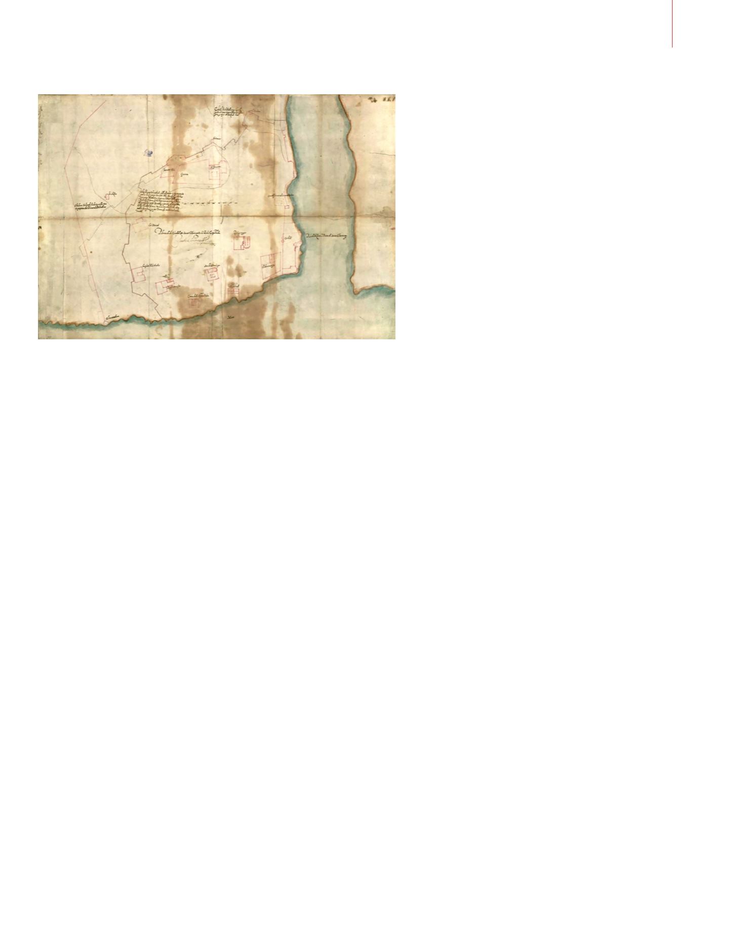
Drawing of the
Colonial City by the
military engineer
Battista Antonelli.
The two plans for
development of the
defensive wall stand
out: the first and larger
one toward the west,
requested by the
residents of the city,
and the second which
reduces the extension
of the fortified
perimeter by Battista
Antonelli.
© Sandro Parrinello